This wide- and large- screen layout
may not work quite right without Javascript.
Maybe enable Javascript, then try again.
Thumbnail Description of
Ipswich
Ipswich is quite a few miles north of downtown Boston in the state of Massachusetts, which in turn is part of the New England region of the country U.S.A, which in turn is located on the continent North America. Ipswich is often categorized both as part of metropolitan Boston and as part of Cape Ann, and is sometimes even thought of as part of the North Shore. (North Shore is a somewhat ambiguous term that occasionally includes the whole Cape Ann area.) Cape Ann can be thought of as the northern analogue of Cape Cod.
Go north from Boston to Route 128 (also known as "the inner beltway" and as Interstate 95), then keep going further north about as far as you've already come. Welcome to Ipswich.
Ipswich now hosts a largish, high-tech employer: EBSCO Publishing. They are mainly housed in old mill buildings originally constructed in the early part of the last century and most famously where Ipswich Hosiery was manufactured. Their part of downtown Ipswich includes the old (but very sturdy) Ipswich Mills Dam across the river that once provided water power to the mill. It is also often called the Sylvania Dam or the EBSCO Dam or even the Ipswich Dam, and is now owned (including liability) by the Town of Ipswich. Through a fortunate confluence of interests of EBSCO and Ipswich, several development projects focussing on the Ipswich river that borders EBSCO's buildings have been undertaken. The fish ladder constructed in 1910 has been replaced with a new one that actually works, and construction of a footbridge and connecting paths to form an easily accessible "riverwalk" has been completed. The riverwalk passes an illustration of several hundred years of Ipswich history in the form of a large intricate mural painted on the side of one of the EBSCO buildings. (A key —and even a matching book— is available to help identify the detailed parts of the mural.) Several earlier footbridges crossed the river —usually on top of the dam— and were used mainly by mill workers. (You can still see the support block of the last footbridge in the middle of the current dam.) The last footbridge was damaged beyond repair then removed in 1973 when a wall accidentally collapsed during the demolition of what was then the Sylvania paint shop building.
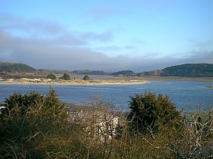
The Town of Ipswich is the last town on the Ipswich River before it flows into the ocean. The river flooded fairly badly in May 2006 and again in March 2010. One of Mass Audubon's wildlife sanctuaries is on the river. The health of the whole river from which many towns draw their water is the principal concern of the Ipswich River Watershed Association. A current issue is how to prevent further Ipswich River flooding damage to downtown Ipswich.
There are five roadway bridges across the Ipswich River in the town of Ipswich, three entirely within the town and two crossing to a neighboring town. The town of Ipswich also contains one railroad bridge and one pedestrian bridge over the Ipswich River. And there are two other roadway bridges in the town of Ipswich, one over the Fox Creek Canal on Argilla Road and the other over Gould's Creek on Labor In Vain Road.
The three Ipswich River roadway bridges entirely in the town of Ipswich are:
the recently rebuilt Green Street bridge used locally,
the almost hidden County Street bridge,
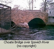
and the Choate bridge that carries traffic through downtown
on Route 1A (and Route 133).
(The Asbury Street bridge off Topsfield/Ipswich Road is
in Topsfield not Ipswich;
Route 1 is
The Choate Bridge is the the oldest remaining double stone arch roadway bridge in North America. (The honor of being the very oldest remaining stone arch roadway bridge in North America belongs to the Frankford Avenue bridge in Philadelphia, which includes a third smaller arch.) Ipswich's Choat Bridge carries the two lanes of traffic (one each way) of State Route 1A, pedestrians on a sidewalk on the upstream side, and various utility pipes and wires tucked away on the downstream side. It was originally constructed twenty feet wide in 1764, then widened to a total of thirty-five feet in 1838. It was repaired and restored in 1989 supposedly for the next century (all the mortar was replaced), but some of its footings had to be repaired again in spring 2006 because of significant flood damage.
The two roadway bridges to other towns are the small Willowdale Road bridge (known in Hamilton as the Winthrop Street bridge) into a back part of Hamilton, and Warner's Bridge which carries Mill Road linking Ipswich and Hamilton. Warner's Bridge (known as the Highland Street bridge in Hamilton), three spans originally constructed of dry-laid stones (no mortar) in 1827-1829, like the Choate Bridge is a historic treasure. Several of Ipswich's bridges were damaged by the Mothers' Day flood of spring 2006; all were fully repaired and reopened, some within weeks or months, and others not until 2009. (Much of the repair work was to substructure or under water. Only the adjustments to the Warner's Bridge parapet are clearly visible to travelers.)
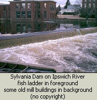
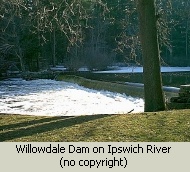
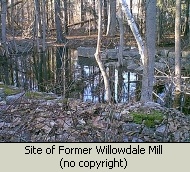
Today there are still two dams across the river in the town of Ipswich, both built to power former mills. The Willowdale Dam was built for the Willowdale Mill (perhaps better known as Manning's Mill), an early textile mill that ran from the 1830's clear through the Civil War and beyond. The buildings are all gone now (some destroyed by a second fire in 1884, some moved); only some stone foundations and some water channels remain. The pond behind Willowdale Dam is now the terminus for Foote Brothers Canoes. The Ipswich Mills Dam (also called Sylvania Dam or EBSCO Dam or Ipswich Dam) was used by several concerns, including the Ipswich Hosiery Factory which peaked nearly a century later than Manning's mill in the 1920's. At least the third dam on the same site, it is now owned by the Town of Ipswich. Some of the mill buildings remain and are now occupied by EBSCO.
Ipswich is a place of great natural beauty and has committed to retaining some of its vistas undeveloped through its Open Space program, which is described in general by a number of webpages and brochures on the Town website. Here's one of those general descriptions of the Open Space program, and here are specifics of property acquisition under the Open Space program. There are many places to walk/hike around Ipswich, including the local portion of the Bay Circuit Trail. Some of the land is part of the Great Marsh which stretches all the way from the backside of Cape Ann to the New Hampshire border and is considered one of the significant natural wonders of the whole east coast. One of Ipswich's principal geographic features is Crane Beach which is built up from ancient sand formations in the White Mountains of New Hampshire carried to the sea by the Merrimack River. Crane Beach is mostly overseen and maintained by The Trustees of Reservation as one of their principal income generating properties. Ipswich citizens though enjoy almost free access to the beach and the castle grounds because of an agreement concluded several decades ago to resolve conflicting legal claims about ownership and access.
Just before the turn of the millenium the town constructed and occupied a combined middle and high school which is quite nice. About half the cost of the building was paid for by the state. The building includes not only both middle and high schools but also a very large very nice auditorium which is used for school events, civic events, and arts events.
The MBTA commuter rail line from Boston's North Station to Newburyport stops in Ipswich. Federal regulations require the sounding of a very very loud (110 decibels!) train horn at most road-railroad grade crossings. Since the sounding of the very loud train horn is a federal regulation, neither Ipswich town hall nor the Ipswich police department nor the MBTA had discretion to eliminate it on their own. As of May 2010, Ipswich had a temporary exception to the sounding of the very loud train horn, but the exception was only temporary (the federal regulatory agency had been patient for several years already and would not continue to renew the temporary exception indefinitely). Permanent quiet zone exceptions are available in many cases with only relatively minor safety upgrades to the roads, but not in the case of most Ipswich crossings because there is some history of car-train accidents at some of them. To get a quiet zone exception throughout the town, yet also avoid the huge expenditure for four-quadrant gates (an estimated total of nearly a million dollars!), among other things Ipswich reconfigured —often significantly— the roads that cross the railroad line, even changing a couple of them to one-way.
For a while several years ago I became involved in the local politics around my children's schools, including funding of the Ipswich public schools (for example Feoffees contributions), our state's requirement to pass the MCAS test to graduate from high school, the federal No Child Left Behind program inspired by Massachusetts, and the education of gifted and talented students. Most intimately related to our public schools are the local property tax rate in Ipswich, the demographic size of Ipswich, the age and sex population distribution of Ipswich, the demographic composition of Ipswich, and the purpose and composition of the local Finance Committee.
Quite a few notable people have been associated with Ipswich over the centuries. Rather than attempt any sort of exhaustive list, here's just a few highlights.
The British, attempting to put their unruly colonists on a shorter leash (or even to punish them:-), revoked the Charter of Massachusetts Bay and in 1686 formed the Dominion of New England in America and installed Governor Edmond Andros, former British governor of New York. Andros and his measures were very unpopular, and —led in significant part by the Town of Ipswich, which was second only to Boston at that time— the whole area became increasingly rebellious.
John Wise, minister of the Chebacco Parish of Ipswich, at a hurriedly called meeting of town leaders and then at a town meeting the next day, convinced Ipswich not to go along with Andros' latest tax scheme. Ipswich maintained the scheme was illegal because it was taxation without representation. Andros promptly clapped many of the leading townsmen in jail and arrested others, thoroughly shocking prominent citizens who had always been treated with more respect. Most of them caved to Andros' demands after only a short time, and begged to be released, apologizing and paying substantial bail. Samuel Appleton however –after eluding arrest for several months– remained defiantly jailed for several more. This pre-echo a century beforehand of the Revolutionary War slogan taxation without representation has led Ipswich to be called the Birthplace of American Independence.
Arthur Wesley Dow was born in Ipswich, then returned as a famed painter and art educator. He founded and served as the director of the Ipswich Summer School of Art for many years around the beginning of the 20th Century. His book Composition helped introduce principles of Japanese Art to a wider audience of American artists. He introduced the use of cyanotypes so any student could quickly photograph an outdoor scene of choice, then return to the studio to work on producing a painting. And he donated several paintings to Ipswich, including a couple that were rediscovered in the school superintendent's office in 2000. Many of those paintings are on display at IpswichMuseum (formerly Ipswich Historical Society).
Cyanotypes were the Polaroids of their day. They were blue on white (not full color, but not exactly black and white either), rather high contrast, tended to fade away at the edges of the frame, and didn't always focus as crisply as we now expect. Such quick-and-dirty images were ideal for painters though, allowing them to remember a scene with just a few minutes effort to snap a cyanotype rather than spending hours sketching it.
The author John Updike lived in Ipswich for many years while his family was growing up. Those years in the 1960s and 1970s were some of his most productive. As is common with writers, there was sometimes tension when intimate tidbits about his neighbors found their way into his fiction. Besides writing, and socializing with many of the townspeople, he was often quite visible as a participant in town events and ceremonies.
One intriguing Ipswich story (well actually the map says it's now Hamilton, but it feels like it's still Ipswich) is how the location identified as Nancy's Corner got its name. Almost all maps show that name on Mill Road near its intersection with Cutler Road, and the U.S. Census lists Nancy's Corner as a populated place. Yet there's actually little to see there and very few signs of habitation - it looks like just one more rural intersection. Why does that particular place have a much more specific name than similar places? It turns out the Nancy of Nancy's Corner was a real person with quite an interesting history.
Ipswich is a very old town with roots that easily stretch back to the time of the pilgrims. Specifically, it's one of the oldest towns in America, having been settled in 1633 and incorporated in 1634. History as well as scenery is important in Ipswich. An excellent place to learn about the past lives of Ipswich is the website of the current town historian Gordon Harris/Ipwich Historic Commission. The Ipswich Historic Commission is a government-related volunteer organization that has sometimes focused mostly on preservation, and other times acted as the principal conveyor of Ipswich history. Another is the IpswichMuseum (formerly Ipswich Historical Society). A third is two Arcadia books of old photographs with extensive explanatory captions, Ipswich and Ipswich Revisted, curated by Bill Varrell via the Ipswich Historical Society (now IpswichMuseum). And a fourth good way to learn more about Ipswich is to think like a tourist, perhaps with help from Olde Ipswich Tours.
The information formerly stored on the storiesfromipswich website (town history, the town's historic houses, etc.) by the town historian has been merged into the former Ipswich Historical Commission website. Here's another description of Ipswich, motivated by genealogical research. Yet another webpage that made it very easy to obtain a wide variety of data about Ipswich was provided by ePodunk until the end of 2019. And here's our local newspaper's current take on Ipswich.
(North America> USA> Massachusetts> Boston Metro North> Ipswich)
Email comments to Chuck Kollars
Time: UTC-5 (USA Eastern Time Zone)
(UTC-4 summertime --"daylight saving time")
 Chuck Kollars' other web presences include
Chuck's books
and
Chuck's movies.
Chuck Kollars' other web presences include
Chuck's books
and
Chuck's movies.
You may also wish to look at Dad's photo album.