This wide- and large- screen layout
may not work quite right without Javascript.
Maybe enable Javascript, then try again.
Preventing Ipswich Flooding
The Mothers' Day 2006 flood did significant damage to downtown Ipswich Massachusetts, and another flood not quite four years later in March 2010 interrupted commerce and threatened major damage again. (Some other notable floods occurred in 1987, 1996, and 2001.) Periodically way more water comes down the Ipswich River than the channel through downtown Ipswich can handle ...period, end of story. And it's getting worse.
There's no getting around it; right now there just isn't any place to put that much water. Long-term, other towns upstream in the watershed need to stop draining more and more runoff rainwater into the Ipswich River and start soaking it back in the ground. But that will take decades to reduce the flow of water. Short-term, Ipswich may need to take unilateral action. One way to do that is to construct a secondary semi-parallel channel that would be wet with the "extra" only during very high water.
Such a secondary river channel is traditionally called a "bypass". As they're almost unheard of in New England, examples come from other parts of the country. One example, the Yolo Bypass in California, has been carrying the floodwaters of the Sacramento River safely around urban areas for over three quarters of a century. Besides protecting 1.7 million people from flooding, it provides significant wetlands and wildlife habitat.
Please enable both JavaScript and CascadingStyleSheets in your web browser (or use an entirely different web browser) to get the most from this page.
Without them there will be no interactivity on this page, although all the data will still display statically.

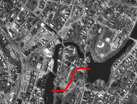
In Ipswich, a secondary channel around the most sensitive parts of downtown could go through Sally's Pond, flow under the 1A curve, skirt the parking area below the Heard House, go behind the Police Station, under County Street, and dump into Turkey Cove via that narrow "pocket park". The aerial photo illustrates this possible route, which would skip past both our old stone arch bridges. The existing elevations seem at first glance to be everywhere within ten feet of what's needed. This route doesn't cross any hills or go too close to any buildings. (Although at first the Heard House seems awfully close to this route, the colonials built it on top of a hill, well above the waters that might flow through such a secondary channel. Our historic Whipple House is also on high ground, safely out of the way of any secondary channel and indeed any flooding at all.)
One thing that makes bypasses so attractive is their completely automatic and passive operation. A low wall is built between the main river channel and the secondary river channel. When the water's not too high, that wall keeps all the water in the main channel. But when a flood comes, some of the water spills over that wall into the secondary channel. The higher the flood, the more water goes into the secondary channel.
Where this bypass would empty into Turkey Cove, conveniently there's one house "missing"; that "pocket park" property currently hosts only a town underground water filtration facility.
A principal reason that bypasses are not typically built in New England is that the land is too developed and has too many different owners. Ipswich has a unique situation though, that makes what's usually too crazy workable after all. Besides there being no buildings in the way, virtually all of the land involved in this route is owned by only two entities, both of which are very pro-Ipswich, and neither of which has thoughts of promoting "development" there: the Ipswich Museum (formerly Ipswich Historical Society) and the Town of Ipswich.
The best guess is the presence of the Ipswich Mills Dam (also called Sylvania Dam or EBSCO Dam or Ipswich Dam) has virtually no effect on downtown flooding, and dam removal wouldn't have any effect either. (As a general rule, "run-of-river" dams like the Ipswich Mills Dam tend to make flooding worse upstream but have little or no effect downstream.) In fact, in our particular case, the dam may very well have slowed the river enough to keep our historic Choate Bridge from collapsing in May 2006.
If you examine that satellite photo closely, you'll see the river's existing channel through downtown Ipswich is noticeably odd. The channel through downtown is neither as wide nor as straight as it is elsewhere. It's easy to imagine from the satellite picture that the river's "preferred" route would have followed the proposed secondary channel route. (But remember we're only talking about a "secondary" channel, not moving the river's main channel.) It's likely some rock formations have forced the river into this unexpected channel; and it's likely construction of a secondary channel will come face to face with that rock.
These floods have already cost individuals and businesses in the Town of Ipswich, as well as the State of Massachusetts, a whole lot; the cost of a more general shared solution that would eliminate further piecemeal expenditures seems justified. The whole floodwall underneath QLF (the Quebec Labrador Foundation) had to be rebuilt. An ancient gray jerry-built building used to sit at the end of South Main Street, touching the Choate Bridge, housing Immie's Bridal Gowns, several other stores, and many apartments. The 2006 flood left soggy wiring in its basement, which eventually ignited and burned up the whole building. The driveway and the parking behind 4 South Main Street disappeared under the water, and the offices normally accessed via the rear of that building became difficult to reach. Coldwell Banker Real Estate in the front of that building was penetrated by the 2006 flood. Both underwater and road-level repairs to the County Street Bridge, and similar repairs to the Choate Bridge, totalled to a considerable expense. Crossing over the channel and continuing back up the other side, two restaurants have been flooded out of the bottom level of the Caldwell Block. All the parking between the channel and Market Street was under too much water to park there. And most of the buildings between the channel and Market Street had to sort through the soggy contents of their basements and replace all their electrical distribution wiring. Now they must restrict the use of their basements, which have become less useful than they should be, as they now know those basements could easily be overwhelmed by flood waters again. The Riverwalk Mural has been damaged, repainted, and damaged again. EBSCO, which invested in significant and expensive flood control measures after the 2006 flood caused considerable damage, still loses one of its parking areas and part of another to flooding. EBSCO's new flood control measures have been effective so far ...but won't be if the water rises a couple more feet to reach and flow in the windows.
(Although conceivably construction of a bypass might also address other problems such as easier fish traversal or boating access, it very well may not. At least it won't make these problems any worse than they already are.)
(Water in the EBSCO building upstream of the dam isn't anything new. A senior citizen remembered that in the old Sylvania days, employees who worked on the bottom floor of what's now the EBSCO building would sometimes be told to wear rubber boots to work because there was lots of water on the floor. In any case, in addition to the pumps they've always had in their cafeteria, EBSCO has now built a massive floodwall around their cafeteria courtyard, and has prepared bright yellow flood barriers for every doorway that could allow water into their buildings.)
Exactly how to build such a thing and exactly who could pay for it are open questions. Here's one tentative list of what we might need though:
- Install a low spill-over wall between the Ipswich River and Sally's Pond behind the Ipswich Mills Dam (also called Sylvania Dam or EBSCO Dam or Ipswich Dam). The wall will need to include a significant skirt on the Sally's Pond side so it doesn't erode.
- Put a section of the 1A curve up on stilts. And cover the ground under the road with something that's erosion-resistant.
- Excavate a channel below the Heard House, behind the Police Station, and under County Street. Remove some of the large old trees in the Heard House side yard. Also, most likely there's significant rock there and blasting will be required.
- Rearrange the water treatment machinery in the County Street pocket park.
- Carry County Street over the new secondary channel on a short clearspan bridge. Both sides likely have rock very near the surface, so no significant excavation nor foundation should be necessary. And furthermore, depending on elevations and tides, that channel may be completely dry during construction so the builders wouldn't have to move or block or even work around any water.
A few other things one might think of are not necessary: We don't need any sort of additional weir (dam) anywhere. We don't need any sort of sluice gate anywhere. We shouldn't need any sort of discharge structure into Turkey Cove, as the side of the cove there is visibly solid rock. And there's no longer any need to move the electrical distribution equipment hidden between the Police Station and the back of the Heard House because it's not there any more! (The new substation on Vermette Court in 2009 made it unnecessary and it was removed.)
Only when a hydrologic engineer tells us will we know for sure whether or not the Ipswich Mills Dam (also called Sylvania Dam or EBSCO Dam or Ipswich Dam) would be needed as part of a bypass (and so should not be removed lightly). An initial guess though is that existing dam would contribute to a bypass, by:
- Raising the water level right where the main and bypass channels would separate; a higher bypass would require less excavation
- Slowing down the flood waters a little right where the main and bypass channels would separate
- Making the water height consistent from year to year, so "flood height" would always be the same even if the channel changed
Without a dam, the operation of a bypass spillover wall might not be sufficiently "automatic".
(North America> USA> Massachusetts> Boston Metro North> Ipswich)
Email comments to Chuck Kollars
Time: UTC-5 (USA Eastern Time Zone)
(UTC-4 summertime --"daylight saving time")
 Chuck Kollars' other web presences include
Chuck's books
and
Chuck's movies.
Chuck Kollars' other web presences include
Chuck's books
and
Chuck's movies.
You may also wish to look at Dad's photo album.