This wide- and large- screen layout
may not work quite right without Javascript.
Maybe enable Javascript, then try again.
Driving Directions to Ipswich
If you're driving from elsewhere in the area, here are several routes
for coming to visit Ipswich:
from Downtown Boston, southern suburbs, and Cape Cod
via Route 1 North,
from western suburbs
via Route 128(I95) North,
from Salisbury, Portsmouth, and Maine
via Route I95 South,
from far north Massachusetts coast such as Newburyport and Plum Island
via Route 1 South,
from New Hampshire and Vermont
via Route I93 South,
or
from far Cape Ann such as Rockport and Gloucester
via Route 128 South.
If you're flying in, see the specific
directions from Boston's Logan Airport.
In any case, you may prefer to
look at a
![]() map.
map.
Avoid coming all the way up Route 1A unless you really want the scenic route. It's winding, slow, and unnecessary.
From Points South Via Route 1 North
If you're coming from downtown Boston, keep going north on 1 past 128(I95). To get started on Route 1 you may need to follow signs for I93 North then take a left exit for the Tobin Bridge (then the very long exit ramp descends from quite high to below ground level in the course of making three quarters of a circle to the left). If you're coming from a southern suburb or Cape Cod, and it's the middle of a weekday or a weekend or nighttime, take 3 north into Boston then 1 north out of Boston. But if it's rush hour(s), take the ring road 128(I95) instead to avoid the worst of the horrible traffic. (The awful traffic snarl through downtown Boston has supposedly been alleviated recently by completion of the big dig, but I've not seen it for myself.) If you're coming from Boston's Logan International airport, although you'll take Route 1 North getting there is sufficiently tricky you should follow the airport specific directions.
Follow Route 1 North a few miles through strip development. After you cross Route 128 the Route 1 you're on will begin interweaving with I95 which follows a very similar route. At one point the road will divide with the left lane remaining Route 1 North and the right lane entering I95. Stay to the left on Route 1. Soon the road, which is mostly notably straight, will swing to the right and cross I95 on a bridge, then swing back to the left again. There will be a couple of forks here. Be sure to stay on the right side of both of them, otherwise you'll either get stuck on I95 or make a giant U turn and head south again. The right forks will lead you off to a traffic light.
Now that there's only one route (even though you've still got a dozen miles to go), follow the directions to enter Ipswich from the south.
From Logan International Airport
These directions may be easier to understand if you're also
looking at a
![]() map.
map.
On the connector road out of the airport parking structure, first swing left with the majority of the lanes (don't take the lane or lanes up the ramp to the Ted Williams tunnel which may be marked I90 or downtown Boston), then stay toward the right. (You may enter the connector road after the big swing to the left and the Ted Williams tunnel if you rent a car.) The road will split several ways: back into the airport; to downtown Boston via the Sumner tunnel; and north on Route 1A. (The middle branch to downtown is often blocked off by a police car with its lights flashing.) Take the rightmost branch, the one that joins Route 1A going north. Follow the signs for Route 1A North ...even if the signs and these directions seem to disagree (these directions were written before the big dig was completed, and might not reflect recent significant changes in those roads).
Soon you'll come to a strange intersection that's part fork and part traffic circle, yet has traffic lights. This is Bell Circle although there may be no signs to confirm this. Bear slightly to the left (the sign says "to Route 1"), following the majority of the cars. The road number will change from Route 1A to Route 60 (the number 1A goes down the right fork at the intersection, where you do not want to go.
Then you'll come to a second traffic circle. This one is large, flat, and more conventional. Two roads cross here, so there are four exits out of the traffic circle. Stay on Route 60. To do that go half way around (that's two exits) the traffic circle counterclockwise, then exit right.
After a while you'll come to a third traffic circle. This one is so large you can't always see the other side, especially since a road overpass cuts right through the middle of it. Get in to it, then get out again at the very next exit for Route 1 North, which is about one quarter of the way around. This traffic circle is so large it's probably a tenth of a mile to that very next exit. The exit from the traffic circle leads slightly uphill into Route 1 North.
Just stay on Route 1 North for a long time, past interminable strip development and large restaurants. Use one of the leftmost two lanes that go down into an underpass near 128(I95) and 129 (or at least stay to the left, otherwise you may wind up taking an exit when you don't want to). Eventually you'll cross Route 128(I95), although you probably won't see it.
Continue following Route 1 North a few miles through more strip development as it interweaves with I95 which follows a similar route. At one point the road will divide with the left lane remaining Route 1 North and the right lane entering I95. Stay to the left on Route 1. After a while the road, which is mostly notably straight, will swing to the right and cross I95 on a bridge, then swing back to the left again. There will be a couple of forks here. Be sure to stay on the right side of both of them, otherwise you'll either get stuck on I95 or make a giant U turn and head south again. The right forks will lead you off to a traffic light.
Now that there's only one route (even though you've still got a dozen miles to go), follow the directions to enter Ipswich from the south.
From Points West and South Via Route I95(128) North
If you're coming from the south or west on I95(128), take the exit onto 1 North. If you miss the exit for 1 North, rather than make a U turn take the very next exit for I95 North and proceed by a slightly different route to where I95 and Route 1 diverge. This is more like a fork than a normal exit, the three lefthand lanes are 128 toward Gloucester and the two righthand lanes are I95 toward New Hampshire. If you see an exit for Forest or Centennial you've missed both Route 1 and I95. Take the Forest/Centennial exit, cross over 128, reenter 128 going south, and immediately take the I95 north exit. If you miss that too, keep going and take the very next exit to Route 1 north.
If you exited onto Route 1 North, follow it a few miles through strip development as it interweaves with I95 which follows a similar route. At one point the road will divide with the left lane remaining Route 1 North and the right lane entering I95. Stay to the left on Route 1. After a while the road, which is mostly straight, will swing to the right and cross I95 on a bridge, then swing back to the left again. There will be a couple of forks here. Be sure to stay on the right side of both of them, otherwise you'll either get stuck on I95 or make a giant U turn and head south again. The right forks will lead you off to a traffic light.
If you instead exited onto I95 North, follow it a few miles past exits that don't seem to make much sense, weaving back and forth over the older Route 1 that follows a similar route. Take exit 50 which may be marked to Topsfield Fair, Route 1, Topsfield, Ipswich, or Danvers. When you're coming off the exit stay to the right, otherwise you'll wind up either getting stuck on I95 or making a giant U turn and going south again. You'll come to a traffic light, with a Mobil and an Exxon station on opposite sides of the street just past the intersection.
Now that there's only one route (even though you've still got a dozen miles to go), follow the directions to enter Ipswich from the south.
From Points North Via Route I95 South
The stretch of I95 South from just a few miles south of the New Hampshire/Massachusetts state border to past the exit you want is a big, fast, isolated road. Don't fall into a trance. You'll miss the exit.
Take exit 54 which may be marked for Georgetown or for Route 133. At the end of the exit ramp turn left/east.
You will cross over I95 on a large bridge that has two lanes each way. At the other side of the bridge the road will narrow to what was once a 2-lane very winding country road, then during 1995-1996 was a connected strip of potholes and construction zones, then finally became a less winding country road. Follow it for several miles to a traffic light at a big intersection with buildings on all four corners. The buildings at the intersection seem to loom up out of nowhere. In the corner on your near right will be the Agawam Diner, which is distinctive for its stainless steel attempt to look like a railroad car, something you hardly ever see any more. In the corner on your far right will be a McDonalds and a parking place for yellow school buses. In the corner on your near right will be a small strip mall with the nearest end being a bank, and on the far right will be a used car lot.
Go straight across Route 1 at this intersection when the light turns green. Now that you're close, follow the directions to enter Ipswich from the north.
From Points North Via Route 1 South
Continue on the notably straight Route 1 South to the Rowley intersection where Route 133 crosses Route 1. This is the only traffic light for a long ways (except for the nearby one for left turns into a shopping plaza). Turn right onto Route 133.
Now that you're close, follow the directions to enter Ipswich from the north.
From Points North Via Route I93 South
Turn off I93 South onto I495 North. Follow I495 for several miles through Andover to North Andover. Take the North Andover exit for Massachusetts Avenue. At the end of the exit ramp turn right up the hill on Massachusetts Avenue. Go about a half mile to the traffic light, then turn left onto 133/125 East.
Follow 133/125 through rolling hills and sweeping turns, past an underpass and a McDonalds on the left. At the next traffic light Asia Garden will be on your left. Go through the traffic light, but not too far. There will be a gas station, a Dunkin Donuts, and some strip mall on the left side of the road, and almost nothing on the right side of the road. The first business on the right side of the road will be the low, small Richardson's Ice Cream. Immediately after Richardson's (before the traffic light) turn right, curving onto 133. (There's no real through road to the left, only some houses and some brush and a dead end.) The road you just turned onto will immediately swerve left and go down a hill, then follow the shore of lake Cochichewick on its right. If you miss cutting the corner after Richardsons, you can turn right at the light as a fallback. Beware the narrow poorly marked roadway though; in particular be sure to keep on the right side of the small traffic island else you may meet another car head on.
Follow 133 East along the lake, through Boxford, and finally into Georgetown. Parts of 133 are named Washington Street, Willow Road, and Andover Road. When you come down a long hill to a traffic light in Georgetown and the main part of downtown seems to be to the left, go straight across the intersection. You will be on a smallish, darkish connector road that skirts behind Georgetown. Don't turn any sharp corners. The road will merge gently onto 133 East again on the other side of downtown.
Continue on route 133 over I95 on a large bridge that has two lanes each way. Then 133 will narrow to what was once a 2-lane very winding country road, then during 1995-1996 was a connected strip of potholes and construction zones, then finally became a less winding country road. Follow it for several miles to a traffic light at a big intersection with buildings on all four corners. The buildings at the intersection seem to loom up out of nowhere. In the corner on your near right will be the Agawam Diner, which is distinctive for its stainless steel attempt to look like a railroad car, something you hardly ever see any more. In the corner on your far right will be a McDonalds and a parking place for yellow school buses. In the corner on your near left will be a small strip mall with the nearest end being a bank, and on the far left will be a used car lot.
Go straight across Route 1 at this intersection when the light turns green. Now that you're close, follow the directions to enter Ipswich from the north.
From Points East and North Via Route 128 South
If you're coming from the northern part of Cape Ann, the fastest route is across state route 133 which leaves 128 near the Gloucester border, goes through Essex, and enters Ipswich by joining Route 1A south of downtown. However if you think you'll get lost that way, just take 128 south. From 128 take the exit for I95 North. If you miss the exit for I95 North, instead of making a U turn, take the very next exit for Route 1 North.
If you exited onto I95 North, follow it a few miles past exits that don't seem to make much sense, weaving back and forth over the older Route 1 that follows a similar route. Take exit 50 which may be marked to Topsfield Fair, Route 1, Topsfield, Ipswich, or Danvers. When you're coming off the exit stay to the right, otherwise you'll wind up either getting stuck on I95 or making a giant U turn and going south again. You'll come to a traffic light, with a Mobil and an Exxon station on opposite sides of the street just past the intersection.
If you instead exited onto Route 1 North, follow it a few miles through strip development as it interweaves with I95 which follows a similar route. At one point the road will divide with the left lane remaining Route 1 North and the right lane entering I95. Stay to the left on Route 1. After a while the road, which is mostly notably straight, will swing slightly to the right then cross I95 on a bridge while swinging back to the left. After the bridge you'll come to a couple more forks. Be sure to stay on the right side of both of these, otherwise you'll either get stuck on I95 or make a giant U turn and head south again.
Now that there's only one route (even though you've still got a dozen miles to go), follow the directions to enter Ipswich from the south.
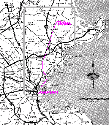
This gives you a birds-eye view
of where Ipswich is
in northwestern Massachusetts.
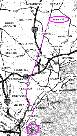
This shows your route from the airport
(or downtown Boston).
To Downtown Ipswich
Entering Ipswich from the South
Start from where Route 1 and I95 diverge. You'll be on Route 1 at the bottom of a hill, there'll be a traffic light just behind you and a Mobil gas station on the left side of the road and a Texaco gas station on the right side of the road. The sign for the Texaco gas station is very tall, and the sign for the Mobil gas station may be too. Route 1, which was built in the 30's, is notably straight. In order to be so straight, it goes up and down more than most newer roads.
Continue north on Route 1 up the hill, down and up
a second hill past a blinking yellow light,
down the second hill past the Topsfield Fair Grounds,
up a third hill straight through the traffic
light at the diagonal crossing of 97, the rest of the way up
the third hill, down a little bit on the other side
of the third hill and up a little bit to the top of a fourth
hill, and down a lot on the other side of the fourth hill.
At the bottom will be a widened intersection
with a traffic light.
There will be an independent gas station on the far left corner
(the sign says something like AL Prime Energy
in blue letters on a yellow background)
and an elevated Dunkin' Donuts on the far right corner.
While the exact color and placement and number of signs may vary,
you'll almost certainly see some sort of sign indicating
Bradley Palmer State Park
is to the right,
and a sign naming the crossroad Ipswich Road
.
At this intersection turn right.
This road has several different names;
it's called Ipswich Road in Topsfield,
Topsfield Road in Ipswich,
and Market Street in downtown Ipswich.
I refer to it as simply Topsfield Road,
although its proper name on both sides where it crosses Route 1
is Ipswich Road.
Note: Maps can make Topsfield Road appear to
be state route 97 since
a part of route 97 in another town has the same name Topsfield Road.
It's not the same road!
Although Route 97 does cross Route 1 on the other side of the hill,
if you follow signs for Route 97 and
expect to end up at the intersection of
Route 1 and Topsfield Road, you'll be disappointed.
Follow Topsfield Road a full six miles,
occasionally glimpsing the Ipswich River on your right.
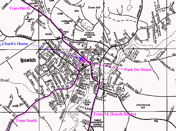
Your route on Topsfield Road will be on the lower left corner of
the local
![]() map of Ipswich.
map of Ipswich.
Bump over the train tracks and see a very small downtown just ahead. Very shortly past the train tracks, just past the brick building (the "castle bank") on your left, take the first left onto Washington Street (it may be called something else like Depot Street for the first very short block). In less than a hundred yards Washington street will take a funny jog right then left again to re-cross the railroad tracks and finally right again to straighten out. Instead of following Washington street all the way through this jog, start to jog right but then continue turning slightly right onto Hammatt street. The two story orange Ipswich Sports Bar comes right up to the sidewalk on your right, while the low columned partially stone faced Ithaki Restaurant is set in the back of its small parking lot on your left.
If you bump over the railroad tracks again, you went too far through the jog, so find an opportunity to turn around. Then try again to turn down Hammatt Street. If you need help, call me at 978 412 0017. (It may be useful to stop at the Richdale store: Go back to Market street where you turned left, and turn left again (not the direction you came from); the low small brick Richdale convenience store will appear immediately on your right, the very first building at street level [not up a flight of stairs].)
Hammatt street is only one block long. One end is where you entered it, the other end is Central Street (with a Citgo gas station opposite). Drive partway to the other end of Hammatt Street, then find a parking place along the street.
Walk across Hammatt Street and walk clear to its end at Central Street.
There will be an
old
![]() bluish green house
on the corner on your left.
Its only obvious sign will be a faux barber pole.
I live on the second floor of that building.
(A fuller description of the house is available too.)
If I know you're coming, or if it's during the day and the barber shop is open,
walk around the corner, start up the wheelchair ramp, but instead of entering
the barber shop door at the top of the ramp
enter the other door (red, marked "44") inside a small porch
near the bottom of the ramp.
Inside walk up the flight of stairs.
You'll find two doors at the top;
my apartment is the door on the right.
bluish green house
on the corner on your left.
Its only obvious sign will be a faux barber pole.
I live on the second floor of that building.
(A fuller description of the house is available too.)
If I know you're coming, or if it's during the day and the barber shop is open,
walk around the corner, start up the wheelchair ramp, but instead of entering
the barber shop door at the top of the ramp
enter the other door (red, marked "44") inside a small porch
near the bottom of the ramp.
Inside walk up the flight of stairs.
You'll find two doors at the top;
my apartment is the door on the right.
Because that outside door is usually locked when the barber shop is closed,
and there's no doorbell and I can't hear knocking there,
you may need to call me via your cellphone.
(As a last resort, go to my outside back door instead.
Retrace your way around the building to the back,
around the corner, down Hammatt Street,
and in where some cars can park between my
![]() bluish green building
and a white building [apartments and dentists office].
On the left of the back of the building
there's an extremely tall set of unpainted stairs.
Walk all the way up both flights.
The door at the top is the back way into my apartment.)
bluish green building
and a white building [apartments and dentists office].
On the left of the back of the building
there's an extremely tall set of unpainted stairs.
Walk all the way up both flights.
The door at the top is the back way into my apartment.)
Entering Ipswich from the North
Travel east on Route 133. In a couple miles it will dead end into Route 1A.
When that happens turn right and follow Route 1A south.
Some of the signs will say 133 East rather than 1A South
because the same piece of road
is both routes here.
1A South here will be fairly straight with only wide sweeping turns.
Your route will soon be on the upper left corner of
the local
![]() map of Ipswich.
map of Ipswich.
Pass the two story brick combined high school and middle school on your right then go up and over a seemingly inexplicable bridge that takes the road across some railroad tracks. When it reaches downtown Ipswich the road suddenly has a very sharp S curve (slow down even more than you already have). Follow the road tightly right with a Dunkin Donuts on your right, then almost as suddenly back tightly left. After you come out of the S there will be a large parking lot on your right containing both a RiteAid Drug with a large red sign and a small houselike structure that's in fact a Sovereign bank branch. Now you're on Central Street in downtown Ipswich.
Travel about an eighth of a mile until you see on your right a blue and yellow laundromat followed by a Cumberland Farms convenience store with gas pumps. (On your left will be the Winthrop elementary school set back so far you'll probably only see trees and grass and the old two-story brick fire station.) Take the next right turn onto Hammatt Street right across from the Citgo station. (Don't be tempted to park near here on Central Street. The area right around the fire station is reserved to give the large trucks enough room to turn, and your car may be towed.)
Immediately find a parking place on the side of Hammatt Street.
After the first few hundred yards there's
a long stretch with no parking on this side,
so you may need to make a U turn and park on the other side of Hammatt Street.
Walk back up Hammatt Street clear to where it began at Central Street.
There will be an
old
![]() bluish green house
on the corner on your left.
Its only obvious sign will be a faux barber pole.
I live on the second floor of that building.
(A fuller description of the house is available too.)
If I know you're coming, or if it's during the day and the barber shop is open,
walk around the corner, start up the wheelchair ramp, but instead of entering
the barber shop door at the top of the ramp
enter the other door (marked "44") inside a small porch
near the bottom of the ramp.
Inside walk up the flight of stairs.
You'll find two doors at the top,
my apartment is the door on the right.
bluish green house
on the corner on your left.
Its only obvious sign will be a faux barber pole.
I live on the second floor of that building.
(A fuller description of the house is available too.)
If I know you're coming, or if it's during the day and the barber shop is open,
walk around the corner, start up the wheelchair ramp, but instead of entering
the barber shop door at the top of the ramp
enter the other door (marked "44") inside a small porch
near the bottom of the ramp.
Inside walk up the flight of stairs.
You'll find two doors at the top,
my apartment is the door on the right.
Because that outside door is usually locked when the barber shop is closed,
and there's no doorbell and I can't hear knocking there,
you may need to call me via your cellphone.
(As a last resort, go to my outside back door instead.
Retrace your way around the building to the back,
around the corner, down Hammatt Street,
and in where some cars can park between my
![]() bluish green building
and a white building [apartments and dentists office].
On the left of the back of the building
there's an extremely tall set of stairs (partly raw wood and partly white).
Walk all the way up both flights.
The door at the top is the back way into my apartment.)
bluish green building
and a white building [apartments and dentists office].
On the left of the back of the building
there's an extremely tall set of stairs (partly raw wood and partly white).
Walk all the way up both flights.
The door at the top is the back way into my apartment.)
Entering Ipswich from Route 1A
Drive north on 1A through Wenham and Hamilton into Ipswich.
Continue between New England Biolabs
(only the sign and driveway are visible because of the screen of trees)
on the right
and open fields of Appleton Farms on the left.
Your route will soon be on the lower edge of
the ![]() local map of Ipswich.
local map of Ipswich.
Continue on Route 1A North past Cable Center/Cable Professional Building/Cable Gardens (formerly Cable Emergency, historically Cable Hospital) and the entrance of Route 133 at an angle from the right, past the Whittier Motel also on the right, and between the Ford dealership on the left and the former Chevrolet dealership on the right. Pass the nondescript telephone company central office and a relatively open area called South Green, both on your left. Watch out for cars stopped or making left turns across traffic onto Argilla road, one of the routes to Crane Beach.
Follow the big S curve first to the left, then between the very old brown Whipple House on the left side and the white China-period Heard House manse on the right side, and finally the last part of the S curve back to the right. Cross the smallish Ipswich River on the old stone Choate Bridge (no superstructure, you may not even notice the slight arch and the low stone sidewalls) into downtown Ipswich. Go straight through the first intersection (but go carefully, four or five roads meet here and lots of folks want to make various left turns, you may need to go around via the right hand lane some cars waiting to turn left). The street you're on will now be called Central Street. After just one quite short block turn left onto Hammatt Street, almost directly across from the Citgo station on your right (or a hundred yards before the old brick two-story fire station on your right).
Immediately find a parking place on the side of the street.
After the first few hundred yards
there's a long stretch with no parking on this side,
so you may need to make a U turn and park on the other side of Hammatt Street.
Walk back up Hammatt Street clear to where it began at Central Street.
There will be an
old
![]() bluish green house
on the corner on your left.
Its only obvious sign will be a faux barber pole.
I live on the second floor of that building.
(A fuller description of the house is available too.)
If I know you're coming, or if it's during the day and the barber shop is open,
walk around the corner, start up the wheelchair ramp, but instead of entering
the barber shop door at the top of the ramp
enter the other door (marked "44") inside a small porch
near the bottom of the ramp.
Inside walk up the flight of stairs.
You'll find two doors at the top,
my apartment is the door on the right.
bluish green house
on the corner on your left.
Its only obvious sign will be a faux barber pole.
I live on the second floor of that building.
(A fuller description of the house is available too.)
If I know you're coming, or if it's during the day and the barber shop is open,
walk around the corner, start up the wheelchair ramp, but instead of entering
the barber shop door at the top of the ramp
enter the other door (marked "44") inside a small porch
near the bottom of the ramp.
Inside walk up the flight of stairs.
You'll find two doors at the top,
my apartment is the door on the right.
Because that outside door is usually locked when the barber shop is closed,
and there's no doorbell and I can't hear knocking there,
you may need to call me via your cellphone.
(As a last resort, go to my outside back door instead.
Retrace your way around the building to the back,
around the corner, down Hammatt Street,
and in where some cars can park between my
![]() bluish green building
and a white building [apartments and dentists office].
On the left of the back of the building
there's an extremely tall set of stairs
(partly raw wood and partly white).
Walk all the way up both flights.
The door at the top is the back way into my apartment.)
bluish green building
and a white building [apartments and dentists office].
On the left of the back of the building
there's an extremely tall set of stairs
(partly raw wood and partly white).
Walk all the way up both flights.
The door at the top is the back way into my apartment.)
This shows downtown Ipswich.
See
written directions for driving into Ipswich from the north
Or see
written directions for driving into Ipswich from the south (except 1A)
Or see
written directions for driving into Ipswich from Route 1A
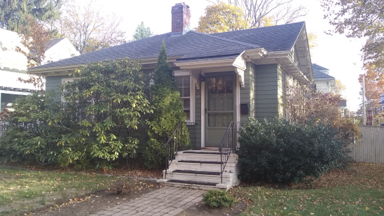
This is a picture of the
house where Chuck Kollars currently lives.
(North America> USA> Massachusetts> Boston Metro North> Ipswich)
Email comments to Chuck Kollars
Time: UTC-5 (USA Eastern Time Zone)
(UTC-4 summertime --"daylight saving time")
 Chuck Kollars' other web presences include
Chuck's books
and
Chuck's movies.
Chuck Kollars' other web presences include
Chuck's books
and
Chuck's movies.
You may also wish to look at Dad's photo album.
Originally an experiment in extensive use of "popup" technology, this page has been reworked so it no longer uses popups at all. Popups were once the darling new technology, but as time has passed they have been largely abandoned. They're not very compatible with tabbed browsing, they were horribly abused, many users don't like them, and modern browsers and systems default to greatly restricting their use or even not allowing them at all.